One of the best places along the South Rim to see and (on a quiet day) hear the Colorado River is Pima Point, where water crashing over Granite Rapids below echoes up the canyon walls. The point is located on the northernmost edge of a wide promontory, allowing visitors a view of over 40 miles of the canyon. Bright Angel Canyon draining out of the north rim is visible to the east, as well as Powell Plateau, Hermit Creek, and the Great Scenic Divide to the west.
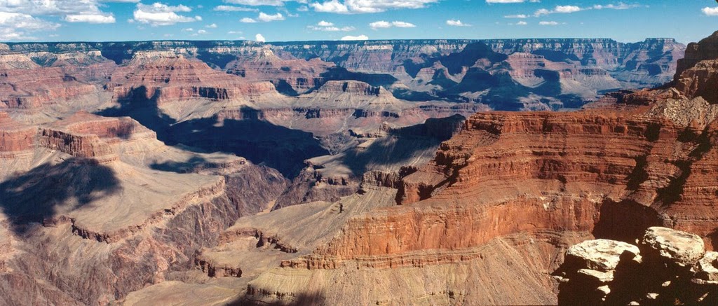
This panoramic view of the Grand Canyon from Pima Point shows the geologic layers of the canyon walls as well as a small section of the muddy Colorado River below.
Photo: NPS
In 1925, the Fred Harvey Company installed a cable tram from Pima Point to their tourist facilities at Hermit Camp, about 3,600 vertical feet below. It was believed to be the longest single-span cable tram in the United States, and was the only rim to inner canyon tramway ever built at the Grand Canyon. The camp was closed in 1930 and burnt to the ground in 1936.
Pima Point was named after a Native American tribe in south central Arizona whom Euro Americans admired as peaceful agrarians. In the early 1900s, the point was sometimes called Hermit Point and Cyclorama Point. Today in the summertime the park’s free buses stop at Pima Point along Hermit Drive to the west of Grand Canyon Village. It can also be reached by foot along the South Rim Trail.
Written By Sarah Bohl Gerke
Suggested Reading:
- Anderson, Michael F. Living at the Edge: Explorers, Exploiters and Settlers of the Grand Canyon Region. Grand Canyon Association, 1998.
- Brian, Nancy. River to Rim: A Guide to Place Names Along the Colorado River in Grand Canyon from Lake Powell to Lake Mead. Flagstaff: Earthquest Press, 1992.