
Navajo women weave a blanket outside a hogan. Photo: Ben Wittick, circa 1890.
Photo: Courtesy of Western History/Genealogy Department, Denver Public Library.
East of Grand Canyon, in a land of stark beauty, broad skies and little rain lies the Navajo Nation. Its people, the Diné (pronounced Dee-nay), are known for their beautiful woolen blankets, clay pottery and silver-and-turquoise jewelry, often made the same way their ancestors made them. The Navajo Nation today is the largest Native American tribe in both population and geographical size. At 27,000 square miles, the reservation is larger than 10 of the 50 states in the Union. The reservation is primarily in northern Arizona, stretching west to Grand Canyon National Park, north into Utah and east into New Mexico. The tribe numbers 250,000 people living on and off the reservation. They hold an annual Navajo Nation Fair to celebrate their culture and their future.
Historically, the Navajos are among the tribes with links to the Grand Canyon. The earliest tree-ring date from a Navajo hogan ruin is 1541 in northern New Mexico, and it is believed they traveled west from there. Archaeological evidence places them in the Grand Canyon area by the late 1600s. Although there is little documentation of the Diné living in the Grand Canyon, their oral history has many references to the canyon and the Colorado River that flows through its inner gorge. The powerful, relentless river is revered as a life force and considered a protector of the Navajo people.
The Diné believe they passed through four worlds before entering this, the Fifth World. Their ancestral lands are bounded by what often are referred to as the four sacred mountains — to the east, Blanca Peak near Alamosa, Colorado; to the south, Mount Taylor near Grants, New Mexico; to the west, the San Francisco Peaks near Flagstaff, Arizona; and to the north, Mount Hesperus in the La Plata Mountains near Durango, Colorado. Likewise, the Navajos have an affinity to four rivers — Rio Grande, Little Colorado, Colorado, and San Juan — that loosely encircle their land. The number four is prevalent in Navajo culture, with the four directions, four seasons, four colors and the first four clans all associated with the four sacred mountains.
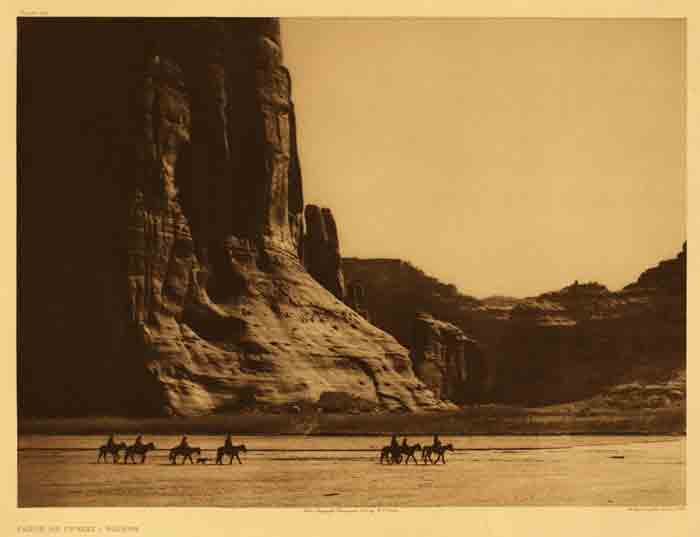
Navajos ride horses in Canyon de Chelly. The eastern Arizona canyon, part of the current Navajo Reservation, was the heart of their homeland in the 1800s. Many of the niches in the cliffs held ruins, evidence of an even more distant past. Photo by Edward S. Curtis, circa 1904.
Photo: Courtesy of Northwestern University Library, Edward S. Curtis’s ‘The North American Indian’: the Photographic Images, 2001.

Several Navajos stand near an unhitched wagon in Shiprock, New Mexico, around 1900.
Photo: H.S. Poley. Courtesy of Western History/Genealogy Department, Denver Public Library
Diné tradition tells of two types of beings, the Earth People and the Holy People. The Holy People placed the four sacred mountains here and instructed the Earth People how to live in a way that maintains harmony and balance. The Navajos still perform more than fifty healing ceremonies designed to meet particular ritual purposes and keep that important balance in life. Some of the ceremonies include visits to sacred sites in the Grand Canyon.
Navajo culture today is a blend of old traditions adapted with new technologies and practices, an adaptability that traces to early times and is reflected in their mythology. Navajo oral history tells of their travels as semi-nomadic hunters and gathers, and of the turkey who gave them corn. They became farmers much like the Pueblo people of the Southwest. When the Spanish entered the area, Navajos learned to herd sheep and weave blankets from the wool. Those intricately designed blankets have become collector’s items around the world.
During the nineteenth century, some Navajos carried on traditional raids for food, animals and captives, a lifestyle common at the time among many peoples. (For more on this feature of life in the Southwest from the 1600s to 1800s, see James F. Brooks’ Captives and Cousins: Slavery, Kinship, and Community in the Southwest Borderlands, published in 2002 by University of North Carolina Press.)
As more white settlers pressed in upon Diné homeland and plans for transcontinental railroads progressed, the U.S. Army set out to capture Navajos and incarcerate them at Fort Sumner in eastern New Mexico. Colonel Kit Carson led a scorched-earth mission in 1863 to force the Navajos’ surrender. Even their usual haven, Canyon de Chelly, was not an adequate hideout from the army. By 1864, about 8,000 Navajos had been forced through hunger to surrender and began the “Long Walk” to the fort on the Pecos River. As many as 5,000 Navajos eluded capture by hiding in the Grand Canyon, Wupatki, Black Mesa and Gray Mountain.
In 1868, Manuelito and other chiefs at the fort signed a peace treaty with the United States, allowing their people to return to their homeland. That 3.5 million acre area, straddling the Arizona/New Mexico line just below Utah and Colorado, is at the heart of today’s much larger reservation. Diné continued raising sheep and weaving blankets. They also added silversmithing to their talents sometime after the Spaniards arrived in the 16th Century. Today, Navajo jewelry made from silver and turquoise is renowned for its beauty.
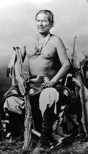
Manuelito was a war chief during the 1860s. This photo was taken between 1868 and 1893.
Photo: Courtesy of Western History/Genealogy Department, Denver Public Library.
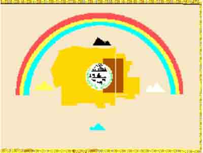
The Navajo Nation flag was designed by Jay R. Degroat, a Navajo from Mariano Lake, N.M., and adopted May 21, 1968.
After the discovery of oil underneath the reservation in the 1920s, the tribe established the Navajo Tribal Council to handle lease contracts. The council was re-organized in 1991 into a three-branch government — executive, legislative and judicial — patterned after the U.S. Government. The Navajo council has 88 delegates representing 110 communities.
The Navajo Nation flag depicts the outline of the Navajo Nation in copper; the original 1868 reservation border is shown in dark brown. The four sacred mountains are shown in their cardinal directions. The rainbow symbolizes Navajo sovereignty, while the sun above two cornstalks and animals shows the traditional economy. Between a hogan and modern house, an oil derrick references another aspect of the Navajo economy.
Written By Patricia Biggs
References:
- Denetdale, Jennifer Nez. Reclaiming Diné History: The Legacies of Navajo Chief Manuelito and Juanita. Tucson: University of Arizona Press, 2007
- Iverson, Peter. Diné: A History of the Navajos. With photographs by Monty Roessel. Albuquerque: University of New Mexico Press, 2002.
- Iverson, Peter, ed. “For Our Navajo People”: Diné Letters, Speeches & Petitions, 1900-1960. With photographs by Monty Roessel. Albuquerque: University of New Mexico Press, 2002.
- Iverson, Peter. The Navajo Nation. Albuquerque: University of New Mexico Press, 1983. c1981.
- Iverson, Peter. We Are Still Here: American Indians in the Twentieth Century. Wheeling, Ill.: Harlan Davidson, 1998.
- Iverson, Peter. When Indians Became Cowboys: Native Peoples and Cattle Ranching in the American West. Norman: University of Oklahoma Press, 1994.
- Morehouse, Barbara J. A Place Called Grand Canyon: Contested Geographies. Tucson: University of Arizona Press, 1996.
- Navajo Nation Cultural Preservation Office.